Key Points to Remember
Fixed wing drones cover far greater distances per flight than rotary-wing alternatives, making them the preferred platform for large-scale aerial surveys.
LiDAR, multispectral, and hyperspectral sensors each serve distinct scientific purposes and cannot simply be interchanged.
UAV-based remote sensing has reduced field survey costs by 60 to 80 percent compared to manned aircraft operations in many documented deployments.
Multispectral cameras detect wavelengths beyond human vision, revealing crop stress, water content, and vegetation health invisible to the naked eye.
The "UAV sensor" category is far broader than cameras alone: gas, thermal, and synthetic aperture radar payloads are all active research frontiers.
1. What Is a Fixed Wing Drone?
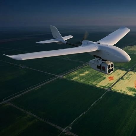
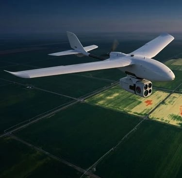
A fixed wing drone is an unmanned aerial vehicle whose lift is generated by stationary wings moving through air, rather than by rotating blades. This seemingly simple distinction carries profound consequences for how these aircraft perform, what payloads they can carry, and which scientific missions they can realistically accomplish.
The underlying aerodynamics trace directly to Bernoulli's principle and the geometry of the aerofoil. As air flows faster over the curved upper surface of the wing than across its flatter lower surface, a pressure differential develops that produces upward lift proportional to airspeed and wing area. Because the wings are fixed, the aircraft must maintain forward velocity to stay airborne, which is why fixed wing UAVs require either a runway, a catapult launch system, or a hand throw, and must land with forward momentum still intact. This constraint is offset by a critical advantage: once at cruise altitude, maintaining lift requires remarkably little energy compared to the constant rotor thrust demanded by a quadcopter or hexacopter.
In practical terms, a mid-range fixed wing drone such as the senseFly eBee X can achieve flight times of 90 minutes or more, covering 500 hectares at standard survey resolution. A comparable-payload quadcopter typically manages 25 to 35 minutes before requiring a battery swap. For large-scale mapping operations across hundreds or thousands of hectares, a commercial plantation, a national park, a post-disaster flood zone, this endurance advantage is decisive.
Fixed wing drones vary considerably in scale, material, and configuration. Foam-construction platforms aimed at hobbyists and entry-level research start below a few hundred dollars and are often sold as fixed wing UAV kits. Professional survey-grade aircraft made from carbon fiber and fiberglass composites, with redundant avionics, GNSS/RTK positioning, and pre-integrated sensor bays, occupy a different price and performance tier entirely. Understanding where on this spectrum a particular mission falls is the first design decision any operator must make.
It is also worth clarifying a terminological distinction that generates persistent confusion: the difference between a drone and a UAV. In common usage the terms are interchangeable, but formally a UAV (Unmanned Aerial Vehicle) refers to the aircraft itself, while a UAS (Unmanned Aircraft System) encompasses the aircraft, its ground control station, communication links, and any support equipment. For scientific and regulatory contexts, the UAS framing matters because certification requirements apply to the entire system, not just the airframe.
2. Fixed Wing vs. Rotary Wing: The Physics of Efficiency
The choice between a fixed wing drone and a rotary wing platform, whether a quadcopter, hexacopter, or octocopter, is not a matter of one being universally superior. It is a question of matching platform physics to mission requirements, and understanding this requires engaging with some basic mechanics.
Rotary wing aircraft generate lift by forcing air downward through spinning blades. The power required to hover scales as the cube of the disk loading, which means that maintaining a stationary position in the air is energetically expensive. A quadcopter hovers by spinning four motors continuously at high RPM, drawing constant current. This is excellent when the mission demands hovering, inspecting a bridge pylon, following a slow-moving subject, or landing precisely in a confined space. It is thermodynamically wasteful when the mission is simply to travel across a large area efficiently.
Fixed wing aircraft, by contrast, do not hover. Their forward momentum is itself the mechanism that generates lift, so cruising flight can be maintained with far lower thrust, and thus lower energy consumption, than any rotary wing hover. The lift-to-drag ratio of a well-designed fixed wing UAV aerofoil typically falls between 10:1 and 20:1, meaning the aircraft generates 10 to 20 units of lift for every unit of drag it must overcome. Rotary wing platforms operating in hover rarely achieve equivalent efficiency.
This efficiency gap is the primary reason fixed wing drones dominate applications where area coverage matters: agricultural surveys, forestry inventory, coastal mapping, pipeline inspection, and archaeological prospection. For missions requiring precise hovering, close-range inspection, or operations in confined airspace, rotary platforms remain the sensible choice.
A third category worth noting is the VTOL (vertical take-off and landing) hybrid fixed wing drone, which takes off and lands like a multirotor but transitions to fixed wing cruise flight. These platforms sacrifice some cruise efficiency compared to pure fixed wing designs but eliminate the need for launch infrastructure, making them increasingly popular for professional survey work in terrain where a catapult setup is impractical.
3. UAV Sensor Types: A Scientific Overview
The term "UAV sensor" encompasses a far wider range of instruments than most non-specialists realize. Understanding the physical principles that distinguish sensor categories is essential for evaluating which payload is appropriate for a given scientific or commercial objective.
At the broadest level, UAV sensors divide into passive and active systems. Passive sensors detect electromagnetic radiation that originates from an external source, typically the sun. RGB cameras, multispectral cameras, and hyperspectral imagers all fall into this category: they measure the reflectance of surfaces across various wavelength bands. Active sensors, by contrast, emit their own signal and measure the return. LiDAR (Light Detection And Ranging) and synthetic aperture radar (SAR) are the most significant active UAV sensor types.
RGB cameras are the most familiar passive sensor, capturing reflected light in the red, green, and blue bands that correspond to human vision. They produce photogrammetric point clouds and orthomosaics useful for general mapping, construction progress monitoring, and volumetric surveys. Their limitation is that they capture only what the human eye sees, which excludes most of the spectral information relevant to biology, geology, and environmental science.
Thermal infrared sensors detect emitted heat rather than reflected light, operating in the 8 to 14 micrometer wavelength range. They are invaluable for identifying heat loss in buildings, detecting wildfires in early stages, locating survivors in search-and-rescue operations, and monitoring industrial equipment for anomalous temperature signatures.
Gas sensors represent a newer frontier: miniaturized electrochemical and optical sensors mounted on UAVs can now detect methane, CO2, nitrogen oxides, and volatile organic compounds at part-per-million concentrations, enabling atmospheric monitoring and leak detection at pipeline infrastructure that would be prohibitively expensive to survey by ground crew.
For a deeper look at the electromagnetic physics underlying sensor technology, the Giroscience guide to space propulsion physics and future tech provides useful background on how energy interacts with matter across the spectrum.
4. LiDAR on Drones: How It Works and What It Costs
LiDAR is among the most scientifically powerful sensors available for UAV platforms, and also among the most expensive. Understanding why requires a brief excursion into how the technology actually functions at a physical level.
A LiDAR system emits pulses of laser light, typically in the near-infrared at 905 nm or 1550 nm, and precisely measures the time elapsed between emission and the return of the reflected pulse. Since the speed of light is a known constant (approximately 299,792 km/s), the round-trip time can be converted directly into a distance measurement with centimeter-level accuracy. By scanning this laser pulse across a scene at thousands of pulses per second, while simultaneously recording the precise position and orientation of the aircraft via GNSS and an inertial measurement unit (IMU), the system builds a dense three-dimensional point cloud of the terrain below.
What distinguishes LiDAR from photogrammetry is its ability to penetrate vegetation canopy. In forested terrain, photogrammetric models derived from RGB or multispectral imagery capture only the top of the canopy, the actual ground surface is invisible. LiDAR pulses, however, can pass through gaps between leaves and return multiple echoes from different heights. This "full waveform" or "discrete return" capability makes LiDAR the gold standard for forestry inventory, archaeological survey beneath jungle canopy, and hydrological modeling.
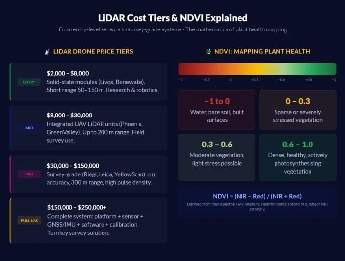
Entry-level LiDAR modules for UAV integration, primarily units from manufacturers such as Livox or Benewake, have fallen to the $2,000 to $8,000 range, making them accessible to academic research groups. Survey-grade systems from manufacturers such as Riegl, Leica, or Yellowscan typically cost $30,000 to $150,000 or more. The platform carrying the sensor, post-processing software licenses, and the expertise required to produce calibrated deliverables add further cost. The honest answer to "how much does LiDAR cost" is: it depends on the required point density, accuracy tolerance, area coverage, and whether the deliverable is a raw point cloud or a finished terrain model.
The physics of LiDAR also creates operational constraints that operators must plan around. Eye-safe wavelengths, maximum pulse energy, and scan angle all affect what regulatory category the system falls into. In the EU and UK, high-powered LiDAR systems may require specific airspace authorization beyond standard UAS operating rules.
5. Multispectral and Hyperspectral Cameras
Of all UAV sensor types, multispectral and hyperspectral cameras have probably had the greatest immediate commercial impact, particularly in precision agriculture, because they reveal biological and chemical information about vegetation that is entirely invisible to conventional photography.
A multispectral camera captures images in a small number of discrete spectral bands, typically between 4 and 12. The red edge band (730 nm) is particularly diagnostically powerful: chlorophyll strongly absorbs red light for photosynthesis, but healthy plant cells reflect strongly in the near-infrared due to the internal structure of the mesophyll. When a plant is stressed, by drought, disease, nutrient deficiency, or pest damage, this red edge reflectance signature changes before any visible yellowing appears. A UAV multispectral camera flying over a large field can therefore detect stress weeks before it is visible to the human eye or a standard drone camera.
From these multispectral bands, analysts derive vegetation indices. The Normalized Difference Vegetation Index (NDVI) is the most widely known: it is calculated as (NIR - Red) / (NIR + Red) and produces values ranging from -1 to +1, where values above approximately 0.3 indicate photosynthetically active vegetation. More sophisticated indices such as NDRE and SAVI have been developed to address specific limitations of NDVI in certain soil and crop contexts.
A hyperspectral camera goes further, capturing continuous spectral data across hundreds of narrow bands, sometimes covering 400 nm to 2500 nm. This produces a full spectral fingerprint for every pixel, enabling identification of specific minerals, detection of trace chemical compounds, and discrimination between plant species at levels of specificity that multispectral data cannot match. The trade-off is data volume, hyperspectral missions generate enormous datasets requiring specialist processing pipelines.
Multispectral camera price for agriculture-grade UAV systems typically ranges from $3,000 to $12,000 for the sensor alone, excluding the drone platform. This context helps explain why UAV multispectral camera queries consistently carry a high commercial CPC despite modest search volume: the buyers are making substantial purchasing decisions.
6. Fixed Wing Drones in Agriculture and Remote Sensing
Precision agriculture has become the flagship application domain for fixed wing UAVs equipped with advanced sensor payloads. Modern commercial farms are often too large for efficient manual scouting, but the variability within them, in soil type, moisture, crop vigor, pest pressure, is too spatially fine-grained for satellite imagery to resolve at operationally useful resolution on a cost-effective revisit schedule.
A fixed wing drone operating at 120 meters altitude with a multispectral camera can survey 200 hectares in a single 60-minute flight, producing georeferenced imagery at 5 to 10 cm ground sampling distance. This combination of coverage, resolution, and temporal flexibility represents a genuine breakthrough for farm management. Fixed wing drones for agriculture are now routinely deployed in vineyards, wheat and maize fields, fruit orchards, rice paddies, and commercial forestry plantations across Europe, North America, Australia, and Brazil.
Drone-based remote sensing extends well beyond agriculture. Coastal managers, hydrologists, mining operators, and conservation biologists all deploy fixed wing UAVs for missions ranging from shoreline change tracking to coral reef extent mapping. The critical advantage in each case is the same: spatial resolution and temporal frequency that neither ground surveys nor satellites can match cost-effectively.
The convergence of drone-based remote sensing with machine learning is particularly significant. Modern convolutional neural networks can be trained to identify individual plant species, count animals, detect invasive species, or classify land cover from UAV multispectral imagery with accuracy levels that approach expert human annotation, and process thousands of hectares in hours. The Giroscience article on multi-modal AI fusion for elderly care explores related AI sensor fusion principles that apply directly to UAV data integration pipelines.

9. Common Mistakes to Avoid
Selecting the sensor before defining the scientific question. The most frequent and costly error in UAV survey planning is choosing a sensor, often a multispectral camera or LiDAR unit, based on availability or budget rather than asking what spectral information is actually needed to answer the research question. A plant stress mapping application may require only 5-band multispectral data; purchasing a 25-band hyperspectral system adds cost, data processing burden, and flight time without scientific benefit.
Ignoring ground control point (GCP) requirements. Fixed wing drones equipped with standard GNSS positioning accumulate positional drift that can introduce horizontal and vertical errors of 1 to 5 meters in photogrammetric products. RTK-GNSS positioning or a robust GCP network are required for sub-10 cm accuracy, and many users discover this only after their first deliverable fails a client accuracy specification.
Underestimating data processing pipeline complexity. A single fixed wing LiDAR or hyperspectral mission can produce hundreds of gigabytes of raw data. Processing this to calibrated, georeferenced products requires specialized software (e.g., LAStools, ENVI, Agisoft Metashape), significant computational resources, and domain expertise that is distinct from piloting skills. The sensor acquisition is often the simplest part of the workflow.
Flying in unsuitable atmospheric conditions. Multispectral and hyperspectral data quality degrades significantly under variable cloud cover because rapidly changing illumination creates inconsistent reflectance values across the mosaic. Best-practice protocols specify data collection within two hours of solar noon, under clear or uniformly overcast skies, with a calibration panel measurement taken before and after each flight.
Neglecting battery thermal management. Fixed wing platforms rely on lithium polymer batteries whose capacity and discharge rate are significantly affected by temperature. Flying at high altitude or in cold conditions can reduce effective endurance by 20 to 40 percent relative to room-temperature specifications, with inadequate warning before abrupt voltage collapse.
FAQ
1. What is a fixed wing drone?
A fixed wing drone is an unmanned aircraft that generates lift through stationary wings rather than rotating blades. Unlike quadcopters, which must spin rotors continuously to stay airborne, a fixed wing UAV relies on forward airspeed interacting with its aerofoil to produce lift through aerodynamic pressure differential. This makes fixed wing designs inherently more energy-efficient in cruise flight, giving them flight endurance of 60 to 120 minutes or more compared to 25 to 35 minutes for typical rotary wing platforms at comparable payload. Fixed wing drones require forward momentum to remain airborne, meaning they cannot hover, and they need either a runway, catapult, or hand launch to get airborne. They excel in applications requiring large-area coverage: agricultural surveys, environmental mapping, pipeline inspection, and topographic modeling.
2. What are fixed wing drones used for?
Fixed wing drones are primarily used for large-area data collection missions where flight endurance and coverage efficiency matter more than hovering capability. In precision agriculture, they carry multispectral cameras to map crop health, detect irrigation deficiencies, and guide variable-rate fertilizer applications across hundreds of hectares per mission. In environmental science and forestry, they carry LiDAR sensors to build high-resolution terrain models, estimate above-ground biomass, and monitor habitat change over time. Coastal and hydrological management agencies use them to survey shoreline change, flood extent, and wetland condition. Military and security applications, border patrol, surveillance, target acquisition, represent significant demand in the defense sector. Increasingly, fixed wing UAVs are also used for atmospheric monitoring, carrying miniaturized gas sensors to map greenhouse gas emissions and air quality over large geographic areas.
3. What is a multispectral camera?
A multispectral camera is an imaging device that captures light in several discrete spectral bands simultaneously, typically including wavelengths beyond the range of human vision such as the near-infrared. Unlike a conventional RGB camera, a multispectral camera might capture 5 to 12 bands spanning roughly 400 nm to 1000 nm. In vegetation, the near-infrared band (around 840 nm) is particularly informative: healthy plant cells reflect strongly in this range, while stressed or dying vegetation shows reduced NIR reflectance. By mathematically combining bands, for example, computing the Normalized Difference Vegetation Index (NDVI) from NIR and red bands, analysts can map plant health, biomass, water content, and disease with spatial resolution and temporal frequency that ground surveys or satellite imagery cannot match cost-effectively.
4. How much does LiDAR cost?
LiDAR costs vary by several orders of magnitude depending on performance specifications and intended application. Entry-level solid-state LiDAR modules from manufacturers such as Livox or Benewake now sell for $2,000 to $8,000. Survey-grade UAV LiDAR systems from Riegl, Leica, YellowScan, or Phoenix LiDAR Systems deliver centimeter-level accuracy and typically cost $30,000 to $150,000 for the sensor alone. Complete systems can reach $200,000 or more. LiDAR drone survey service costs, when contracted from a specialist operator, typically range from $500 to $3,000 per square kilometer depending on specification, logistics, and deliverable type.
5. What is the difference between a fixed wing and a rotary wing drone?
Fixed wing drones generate lift through stationary aerofoil-shaped wings, exactly as a conventional aircraft does. Rotary wing drones, quadcopters, hexacopters, and helicopters, generate lift by spinning blades. The fundamental physical consequence is energy efficiency: fixed wing aircraft in cruise can achieve lift-to-drag ratios of 10:1 to 20:1, translating into long endurance of 60 to 120+ minutes. Rotary wing platforms require continuous high-power rotor thrust just to hover, limiting endurance to 25 to 40 minutes for most commercial platforms. The choice between platforms should be driven by mission requirements: area coverage favors fixed wing; point inspection, confined access, and low-speed tracking favor rotary wing.
6. Fixed wing drone vs. quadcopter: which is better for surveying?
For large-area surveying, anything from 50 hectares upward, a fixed wing drone is almost always the more cost-effective and operationally efficient choice. A fixed wing platform can survey 200 to 500+ hectares in a single flight; a quadcopter typically covers 20 to 60 hectares before needing a battery change. Fixed wing platforms also typically achieve more consistent ground sampling distance across a survey area because of their more stable forward flight. For small areas below 20 to 30 hectares, or for applications requiring vertical takeoff in confined terrain, a quadcopter or other multirotor may be preferable. VTOL fixed wing hybrids increasingly offer a practical compromise for professional survey work in terrain without suitable launch areas.
7. What is drone remote sensing?
Drone remote sensing is the practice of using unmanned aerial vehicles to collect geospatial data about the Earth's surface, atmosphere, or vegetation cover from altitude, by detecting electromagnetic radiation reflected or emitted by the target without physical contact. UAV remote sensing platforms can achieve ground sampling distances of 1 to 10 cm at typical survey altitudes of 50 to 150 meters, resolving individual plants, tree crowns, building features, or geomorphic units that satellite sensors miss entirely. The data types collected include RGB photography, multispectral and hyperspectral imagery, LiDAR point clouds, thermal imagery, and atmospheric gas concentration fields, each serving distinct scientific and commercial applications.
8. What is the difference between a drone and a UAV?
In everyday conversation, "drone" and "UAV" are used interchangeably. The distinction becomes relevant in technical and regulatory contexts. UAV (Unmanned Aerial Vehicle) refers specifically to the aircraft itself, the airframe, propulsion system, and onboard avionics. UAS (Unmanned Aircraft System) is the broader and more formally correct term that encompasses the UAV, its ground control station, the communication datalinks, any launch and recovery equipment, and the human operators. "Drone" has no formal regulatory definition in most jurisdictions. For regulatory filings, airspace requests, and scientific publications, UAS or UAV terminology is preferred for precision. This distinction also matters for discussions of the science of UAP physics and AI at Giroscience, where definitional clarity about aerial platforms is essential.
Conclusion
Fixed wing drones have evolved from their origins as military surveillance platforms into sophisticated scientific instruments that are genuinely transforming how we observe, measure, and manage the Earth's surface. The key insight of this article is that the airframe is only half the story: the sensor payload determines what scientific questions can be answered, and matching the right sensor physics to the right mission objective requires understanding the spectral properties of the phenomena being measured, not just the specifications on a product sheet.
LiDAR has democratized three-dimensional terrain modeling, multispectral cameras have put plant physiology mapping within reach of individual farms and research groups, and hyperspectral imaging is enabling mineral and ecological applications that were once confined to spaceborne instruments. The physics underlying these sensors, time-of-flight laser ranging, differential spectral reflectance, quantum detector sensitivity, are not peripheral technical details but the core scientific principles that explain both the capabilities and the limitations of each system.
As battery energy density continues to improve, as miniaturized sensor payloads become lighter and cheaper, and as autonomous flight software matures, the operational envelope of fixed wing UAVs will continue to expand. The fusion of UAV remote sensing data with machine learning inference pipelines is already producing operationally deployed precision agriculture services, near-real-time wildfire monitoring systems, and automated environmental compliance reporting tools. Understanding the scientific principles at the foundation of these systems, as explored throughout this article, is essential for anyone seeking to deploy, evaluate, or commission drone-based remote sensing work with confidence.
External References
EASA (European Union Aviation Safety Agency). "Easy Access Rules for Unmanned Aircraft Systems." EASA, 2024.
Tmušić, G., et al. "Current Practices in UAS-based Environmental Monitoring." Remote Sensing, 12(6), 1001 (2020).
Wallace, L., et al. "Assessment of Forest Structure Using Two UAV Techniques: A Comparison of Airborne Laser Scanning and Structure from Motion (SfM) Point Clouds." Forests, 7(3), 62 (2016).