Key Points to Remember
Divergent boundaries are zones where two tectonic plates move apart from each other, creating new crust in the process.
They occur in two environments: oceanic plates (forming mid-ocean ridges) and continental plates (forming rift valleys).
The Mid-Atlantic Ridge stretches 65,000 km and is the largest geological feature on Earth.
Iceland sits directly on the Mid-Atlantic Ridge, making it one of the most volcanically active places on the planet.
Plate separation occurs at rates between 2.5 cm/year (Mid-Atlantic Ridge) and 15 cm/year (East Pacific Rise).
Divergent boundaries are classified as constructive margins because they continuously generate new oceanic crust.
The East African Rift Valley is a continental divergent boundary currently splitting Africa into two separate landmasses.
Executive Summary
Divergent science sits at the heart of how our planet continuously rebuilds itself. At divergent plate boundaries, two tectonic plates move apart, and the gap left behind is immediately filled by molten rock rising from the mantle. This process, known as seafloor spreading, has been reshaping Earth's ocean floors and continents for hundreds of millions of years. The results are dramatic: underwater mountain ranges stretching tens of thousands of kilometers, volcanic islands born from the sea, and vast rift valleys tearing continents apart in slow motion. From the cold depths of the Mid-Atlantic Ridge to the sun-baked floor of the East African Rift Valley, divergent boundaries are among the most geologically active zones on Earth. This guide explains what divergent boundaries are, how they form, where they are located, and what remarkable landforms they create, making the complex science of plate tectonics accessible and clear.
Table of Contents
1. What Is a Divergent Boundary? Simple Definition
In divergent science, a divergent boundary, also called a constructive margin or extensional boundary, is a location where two tectonic plates move away from each other. The word "divergent" comes from the Latin divergere, meaning "to go in different directions," and this describes the process precisely. Rather than colliding or sliding past one another, the plates at these boundaries are being pulled apart by convection currents deep within Earth's mantle.
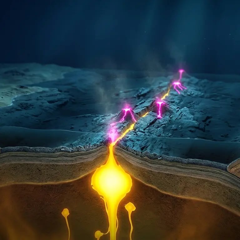
The simple definition is this: where two plates separate, a gap forms. That gap is immediately filled by hot magma rising from the mantle below. As this magma reaches the surface, it cools and hardens into new rock, forming fresh crust. This means that divergent boundaries are the birthplaces of new crustal material, constantly generating rock that pushes older material away from the boundary zone.
This process is fundamentally different from what happens at convergent boundaries, where plates collide and one is forced beneath the other in a process called subduction. At divergent boundaries, no crust is destroyed. Instead, the boundary itself acts as a geological factory, producing new oceanic crust at a steady and measurable rate.
Divergent boundaries come in two principal types, depending on the nature of the plates involved. Oceanic divergent boundaries occur where two oceanic plates separate, typically forming mid-ocean ridges: vast undersea mountain chains running along the center of ocean basins. Continental divergent boundaries form where a continent is being rifted apart, producing dramatic rift valleys that can eventually evolve into new ocean basins over millions of years.
The concept of divergent boundaries emerged from the broader theory of plate tectonics, which was only formally established in the 1960s. Before that, geologists had noted oddities such as the remarkably similar shapes of continents on opposite sides of the Atlantic Ocean, and the surprising discovery of very young rock at the center of ocean floors. It was the confirmation of seafloor spreading by scientists including Harry Hess and Drummond Matthews that cemented the role of divergent boundaries in reshaping Earth's surface. Just as understanding the basic physics behind motion is essential in fields like kinematic equations, understanding the mechanics of plate separation is foundational to all of Earth science.
2. How Divergent Boundaries Form: The Geological Process
The formation of a divergent boundary begins far beneath Earth's surface, deep in the mantle. The driving force is mantle convection, a process in which hot, semi-fluid rock in the mantle rises toward the surface, spreads laterally, cools, and sinks back down, creating slow circulation patterns that can persist for millions of years. This circulation exerts tectonic stress on the overlying lithosphere, the rigid outer layer of Earth that includes the crust and the uppermost mantle.
When mantle convection pulls two sections of lithosphere in opposite directions, extensional forces begin to stretch and thin the crust. In continental settings, this stretching causes the crust to crack along normal faults, producing a series of parallel fractures. The blocks of crust between these faults drop downward under gravity, forming a graben, or rift valley. Over millions of years, as the rift widens, the thinned continental crust eventually breaks apart entirely, seawater floods in, and a new ocean basin is born.
In oceanic settings, the process is more straightforward. As two oceanic plates pull apart, decompression melting occurs: the decrease in pressure as the plates separate allows the mantle rock to partially melt even without any increase in temperature. This melt, called magma, rises buoyantly through the crust and erupts at the ocean floor, producing basaltic lava flows that cool rapidly in the cold seawater. Layer by layer, these eruptions build up to form mid-ocean ridges, underwater mountain ranges that tower several kilometers above the surrounding ocean floor.
The rate at which new crust forms depends on the spreading rate. Slow-spreading ridges, such as the Mid-Atlantic Ridge at roughly 2.5 cm per year, tend to have rugged, irregular topography with steep rift valleys at their crests. Fast-spreading ridges, such as the East Pacific Rise at up to 15 cm per year, develop broader, smoother profiles with shallower central valleys. These differences reflect how quickly the new crust has time to cool and solidify before being pushed aside by the next eruption.
One of the most important consequences of new crust formation at divergent boundaries is the phenomenon of magnetic striping. As basaltic magma cools below a critical temperature, iron-bearing minerals align with Earth's magnetic field and become permanently magnetized. Since Earth's magnetic field has reversed direction many times throughout geological history, the ocean floor records these reversals as alternating stripes of normal and reversed magnetization, symmetrically arranged on either side of the ridge. This striping pattern was one of the key pieces of evidence that confirmed seafloor spreading and, with it, the theory of plate tectonics. The behavior of magnetic minerals in cooling rock is closely related to broader principles of magnetism studied in fields such as electromagnetism and magnetic force.
3. Where Are Divergent Plate Boundaries Located?
Divergent plate boundaries are found on every ocean floor and within several continents. The vast majority of active divergent boundaries run along the seafloor, forming the global mid-ocean ridge system, a connected network of underwater mountain ranges stretching approximately 65,000 km in total length. This makes it the single largest geological feature on Earth, covering roughly 23% of the planet's surface.
The most studied and well-known oceanic divergent boundary is the Mid-Atlantic Ridge, which runs from the Arctic Ocean southward through the middle of the Atlantic basin, past the tip of Africa, and connects to the other branches of the ridge system. It separates the North American Plate from the Eurasian Plate in the north, and the South American Plate from the African Plate in the south. The Mid-Atlantic Ridge has been widening the Atlantic Ocean at a rate of approximately 2.5 cm per year since the breakup of the ancient supercontinent Pangaea began roughly 175 million years ago.
In the Pacific, the East Pacific Rise forms a divergent boundary separating the Pacific Plate from several smaller plates including the Nazca, Cocos, and Antarctic plates. It is one of the fastest-spreading boundaries on Earth. The Indian Ocean Ridge system similarly connects to the global ridge network, while the Arctic Mid-Ocean Ridge runs beneath the Arctic Ocean.
On land, the most significant continental divergent boundary is the East African Rift System, a 3,000 km-long fracture zone running from the Afar Triangle in Ethiopia southward through Kenya, Tanzania, and Mozambique. This rift is actively tearing the African continent apart, and geologists predict that over the next 5 to 10 million years, the eastern portion of Africa (sometimes called the Somali Plate) will separate from the main African continent, eventually forming a new ocean basin.
Another important continental divergent zone is found in Iceland, where the Mid-Atlantic Ridge actually emerges above sea level, making it one of the few places on Earth where a divergent boundary can be explored on foot. The American-Eurasian plate boundary runs directly through the island, expressed as a visible rift valley that crosses Iceland from northeast to southwest.
4. Real-World Examples of Divergent Boundaries
The best real-world examples of divergent boundaries illustrate the extraordinary variety of landscapes and geological phenomena that these tectonic zones produce. Each location tells a different chapter of the same story: plates pulling apart, new material rising, and Earth's surface being permanently transformed.
The Mid-Atlantic Ridge and Iceland
The Mid-Atlantic Ridge is the archetypal oceanic divergent boundary. Running 16,000 km from Iceland in the north to Bouvet Island in the south, it marks the boundary between some of Earth's largest tectonic plates. Although most of the ridge sits several kilometers beneath the ocean surface, Iceland represents a remarkable exception, where the combined effects of the ridge and a mantle plume (a particularly hot column of mantle material) have produced enough volcanic output to build an island above sea level.
Iceland's position directly on a divergent boundary makes it one of the most geologically active places on Earth. The island experiences frequent earthquakes and volcanic eruptions, and its landscape bears the unmistakable marks of rifting: fissures, grabens, and volcanic craters aligned along the northeast-southwest trend of the ridge. The Thingvellir National Park in Iceland offers a stunning surface expression of the divergent boundary, where visitors can walk in the rift valley between the North American and Eurasian plates. The rift at Thingvellir is widening at approximately 2 cm per year, a rate that is imperceptibly slow on a human timescale but geologically rapid.
The East African Rift Valley
The East African Rift System provides the most dramatic example of a continental divergent boundary currently in action. This 3,000 km-long system of faults and volcanic zones is where the African continent is being stretched apart. The rift has produced some of Africa's most iconic landscapes: the deep lakes Tanganyika, Malawi, and Albert fill rift basin depressions; the volcanic peaks of Kilimanjaro and Mount Kenya rise along the rift margins; and the Afar Depression in Ethiopia drops to 155 meters below sea level in places, one of the lowest points on the African continent.
The East African Rift also hosts some of the world's most significant paleoanthropological sites. The ancient lake beds and volcanic ash layers of the rift valley have preserved fossil evidence of human evolution over millions of years, making this geological structure as important to biology as it is to geology.
The Red Sea
The Red Sea represents a more advanced stage of continental rifting than the East African Rift. The Arabian Peninsula was attached to Africa until approximately 30 million years ago, when rifting began to separate the two landmasses. Today, the Red Sea is a young ocean basin roughly 300 km wide, still spreading at its center. It provides a perfect natural laboratory for studying how continental rifts eventually evolve into full-fledged ocean basins.
5. What Landforms Do Divergent Boundaries Create?
One of the most compelling aspects of divergent science is the sheer variety of landforms that these boundaries produce. The type of landform depends primarily on whether the diverging plates are oceanic or continental in nature, and on the spreading rate.
Mid-ocean ridges are the most abundant landform associated with oceanic divergent boundaries. These enormous underwater mountain chains rise 2 to 3 km above the surrounding ocean floor and can be hundreds of kilometers wide. The central portion of a slow-spreading ridge like the Mid-Atlantic typically features a rift valley 1 to 2 km deep, flanked by walls of volcanic rock. Fast-spreading ridges like the East Pacific Rise have a shallower, broader profile. The rocks found at mid-ocean ridges are almost exclusively basalt, a fine-grained volcanic rock formed from rapidly cooling magma.
Rift valleys, by contrast, are the signature landform of continental divergent boundaries. When a continent begins to rift apart, extensional forces cause the crust to thin and fracture along parallel normal faults. Blocks of crust between fault pairs drop downward, forming long, linear valleys with steep escarpments on either side. The floor of the rift valley can drop hundreds to thousands of meters below the surrounding terrain. The East African Rift Valley, for example, reaches depths of over 600 meters in places, and its flanking escarpments rise more than 2,000 meters above the valley floor.
Volcanic islands form when the seafloor at a mid-ocean ridge builds up sufficiently to breach the ocean surface. Iceland is the most prominent example, but the Azores in the Atlantic and the Galapagos Islands in the Pacific were also shaped in part by proximity to divergent boundaries and mantle plumes. These islands are typically composed of basaltic rock and host numerous active or recently active volcanoes.
Hydrothermal vents are another remarkable feature of mid-ocean ridges. Cold seawater percolates down through fractures in the ocean floor, is heated by the hot rock below, and rises back to the surface as superheated, mineral-rich fluid. These vents support unique ecosystems independent of sunlight, with bacteria, tube worms, and other organisms thriving on chemical energy rather than photosynthesis. The thermal properties of the surrounding rock and fluid exchange closely relate to concepts explored in the study of specific heat capacity.


6. Divergent Boundaries and Volcanic Activity
Volcanic activity is a defining characteristic of divergent boundaries, particularly along mid-ocean ridges. In fact, mid-ocean ridge volcanoes collectively produce more lava than all other types of volcanism on Earth combined, making them the most prolific volcanic system on the planet, even though most of this activity occurs unseen beneath kilometers of ocean water.
The volcanic mechanism at divergent boundaries differs significantly from the volcanism associated with subduction zones or hot spots. At a divergent boundary, magma rises not because of water-rich fluids lowering the melting point of rock (as at subduction zones), but through decompression melting: as plates pull apart, the pressure on the underlying mantle rock decreases. When pressure drops sufficiently, the rock melts even though its temperature has not increased. This produces large volumes of basaltic magma that erupt relatively quietly in comparison to the explosive eruptions common at continental volcanoes.
Along the Mid-Atlantic Ridge, eruptions occur regularly but typically go undetected because they happen at ocean depths of 2 to 3 km. The lava flows quickly cool upon contact with seawater, forming characteristic pillow basalts, rounded blobs of solidified lava stacked layer upon layer to build up the ridge structure.
At continental divergent boundaries and in places like Iceland where the ridge breaks the surface, the relationship between volcanism and rifting is more complex. The Afar Triangle in Ethiopia, where the East African Rift, the Red Sea Rift, and the Gulf of Aden Rift all meet, is one of the most volcanically intense regions on land. Here, the crust has thinned so dramatically from rifting that it now closely resembles oceanic crust in composition, and eruptions of fluid basaltic lava are common.
Iceland's volcanic landscape provides a visible surface expression of ridge volcanism. Eruptions along the central rift zone occur every few years on average, and the island's numerous lava fields, calderas, and volcanic fissures record millions of years of accumulated volcanic output. The 2010 eruption of Eyjafjallajokull and the more recent 2021 and 2023 eruptions on the Reykjanes Peninsula both occurred along fault systems directly related to the Mid-Atlantic Ridge divergent boundary beneath Iceland.
7. Are Divergent Boundaries Constructive or Destructive?
In the language of plate tectonics, divergent boundaries are definitively classified as constructive plate margins. This classification reflects the fundamental geological process occurring at these boundaries: rather than destroying existing crust, divergent boundaries are continuously creating new crustal material.
At a mid-ocean ridge, the production of new basaltic crust is relentless. As two plates separate, magma rises to fill the gap, cools, and becomes part of the plates themselves, which are then carried away from the ridge on either side. Over millions of years, this process has built up vast ocean basins. The Atlantic Ocean, for example, did not exist 200 million years ago. It was created entirely by the ongoing activity of the Mid-Atlantic Ridge, which continues to widen the ocean by approximately 2.5 cm per year.
This constructive character distinguishes divergent boundaries sharply from destructive margins, the term used for convergent boundaries where one plate is subducted beneath another and old oceanic crust is recycled back into the mantle. Earth maintains an approximate balance between the creation of new crust at divergent boundaries and the destruction of old crust at subduction zones, which is why the total surface area of Earth's tectonic plates remains roughly constant over geological time.
The term "constructive" has a practical implication for understanding the geological hazards associated with divergent boundaries. While they do produce earthquakes and volcanic activity, the earthquakes at divergent boundaries are generally shallow and moderate in magnitude, typically not exceeding magnitude 7. This is because the new crust being formed is thin and hot, lacking the rigidity required to store and release the enormous elastic energy associated with the devastating earthquakes at convergent or transform boundaries.
8. Divergent vs. Convergent and Transform Boundaries
To fully appreciate divergent science, it is useful to understand how divergent boundaries compare with the other two principal types of plate boundary. Earth's tectonic plates interact in three fundamental ways, and each produces a distinct set of geological features and hazards.
Divergent boundaries, as detailed throughout this article, are where plates move apart. They are characterized by the creation of new crust, mid-ocean ridges or rift valleys, shallow earthquakes, and basaltic volcanism. They are constructive margins.
Convergent boundaries are where two plates move toward each other. The outcome depends on the types of plates involved. When an oceanic plate meets a continental plate, the denser oceanic plate is forced beneath the lighter continental plate in a process called subduction. This produces deep ocean trenches, volcanic mountain ranges (such as the Andes), and the world's most powerful earthquakes. When two continental plates collide, neither subducts easily, and the crust crumples upward to form massive mountain ranges such as the Himalayas. Convergent boundaries are destructive margins.
Transform boundaries are where two plates slide horizontally past each other with no creation or destruction of crust. The most famous example is the San Andreas Fault in California, where the Pacific Plate slides northward past the North American Plate. Transform boundaries are associated with intense, shallow earthquakes but relatively little volcanism.
A useful way to remember the distinction is: divergent boundaries build, convergent boundaries destroy or crumple, and transform boundaries grind. In practice, many plate boundaries are not purely one type. Divergent boundaries are often offset by transform faults, creating zigzag patterns visible in bathymetric maps of mid-ocean ridges. These transform fault segments connect segments of the ridge and accommodate the geometric mismatch between spreading centers.